Urban Development Kaliningrad
Kaliningrad, Russia
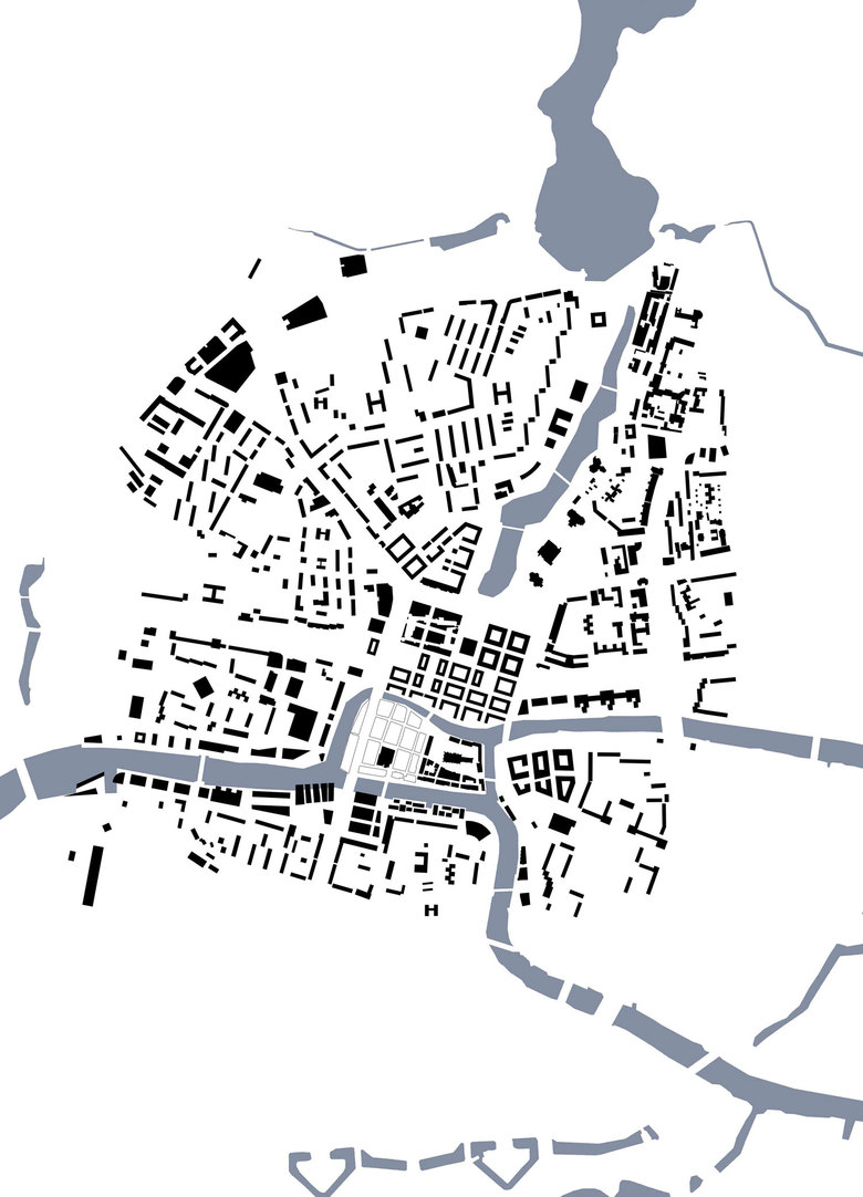
BASIS – The most important connecting elements of the historic city of Königsberg and modern Kaliningrad are landscape and topography. Not only historic buildings and neighborhoods or new traffic highways, created after the second world war, but also the location on the river Pregel, the course of the river through the city and the seaside location characterize the special situation of the city. The restoration of the course of the natural terrain was therefore a top priority to design. Others like economic, functional and formal aspects are subordinate or arising logically. Frankly formulated: Not the change and adaptations of today's traffic, the new functional mixture, the formation of a cultural center in the "Heart of the City" are the key components of the idea, the idea results from the topography. The design goals are: A high degree of urban density in the northern area with attractive cultural, commercial facilities, hotels and service areas and a high quality of living in the south of the competition area - but also the unbundling of transport and an attractive network of pedestrian pathways. The restoration of the course of the historic, respectively natural terrain also contributes significantly to eliminate the distinct break between "Altstadt" and the "Königsberg". This means a better connection of neighborhoods and a better mixture of inner-city and residential functions. A compact urban area with a unified appearance is made possible.
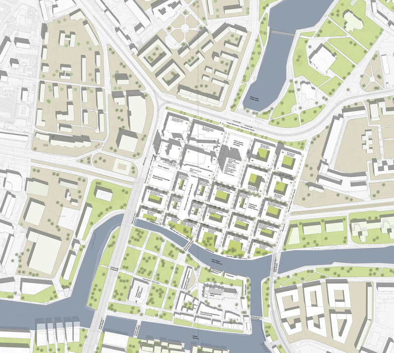
URBAN DESIGN – The main competition area (Central Square and „Altstadt“) is divided into 25 rectangular areas between 110 x 80 m and 55 x 60 m. These proportions corresponds very well with the excellent functioning structures of international major cities. The depth of the districts decreases from north to south according to the decrease in density of use towards the river. Two of these districts are not and other ones only partially built upon. In this way, together with the road hierarchy, a graded open space system of public streets and squares arises. The fringe of the „Kaiserplatz“ would also be restored as well as the historic market of „Altstadt“. The area northern of the former house of the Soviets represents the remains of the "central place" connects to the free space around the castle pond in addition to ist function as a public square. The areas provided for development should have different character - they can be realized seperately from each other in time and space and independent by different investors, developers or public clients. However, this scheme enables in different ways the integration of historical elements, parts of buildings, room corners or facade replicas, in order to account for the "genetic code" of the city. Even incomplete realizations offers independent and fully functional solutions which improve the urban and spatial situation in any case. This also applies to the technical infrastructure: the road network and the structural and spatial pattern of streets and squares also consistently follows the technical supply and disposal.
RECONSTRUCTION OF THE CASTLE? – According to the design principles, the reconstruction of the castle or rather the reconstruction of an only one part is generally possible, but not recommended for economical, functional and sociocultural reasons.
In spite of the fact, that historic buildings are important in many ways, for example as identity-giving places or signs we have to consider very carefully what parts of the past should be revitalized with a view to a former using for political interests, for culture and education, libraries, university buildings and so one. Thats why we suggest a pragmatic approach: What are important urban - spatial, architectural and functional elements of the destroyed castle building - in the sense of that "genetic code"? On the one hand there is the building mass and the significant tower in the southwest, which almost had landmark character and was an important part of the former skyline. On the other there are the yard of the castle as a semi- public space – once with more intimate character than nowadays and the castle terraces in the south. It is quite possible to integrate and revive these elements in a modern architectural and urban concept.
ARCHITECTURE – The architecture of the new city center based on the urban concept, mentioned above, and follows the particular building typology of the location and intensity of use. Basically, every district as well as every plot can be planned, financed and realized individuell and with different formal expressions.Many different sorts and types of materials, colors and shapes are possible, but certainly not suitable for defining a new cultural center. On one hand, the functional possibilities of the concept are advantageous in extensions, alterations, replacement of functions. But for large, design heterogeneity would have an adverse influence. For this reason, it is proposed to develop principles and rules to accompany, support and control in the medium and long term design process, as you can recognize with first ideas in this competition design. It is important to find the balance between variability, functional openness and an unifying, representative appearance. This requires a graduated system for the development of height and construction mass development and also a balanced distribution of volumes and open spaces. At the edge of the area the arrangement of some high-rise buildings (for example office and hotel towers) is recommended - an idea that is based on the well-known urban concept of the "Crown of the City" and offers advantages to the city's skyline and the orientation. "House of Soviets": The uncompleted building occupies a special position on the site, among other things reflecting the ambivalent attitude of the Kaliningrad population: Between rejection and demands for demolition, it has also become a kind of landmark, within the meaning of a sign, orientation guide and testimony of the Soviet neo-brutalism. In this case too, the authors argue for a pragmatical future handling: The building should be preserved, but to provoke an exceptional position in the new urban context again, it has to be modified carefully to be recognized as a modern, multi-functional building.
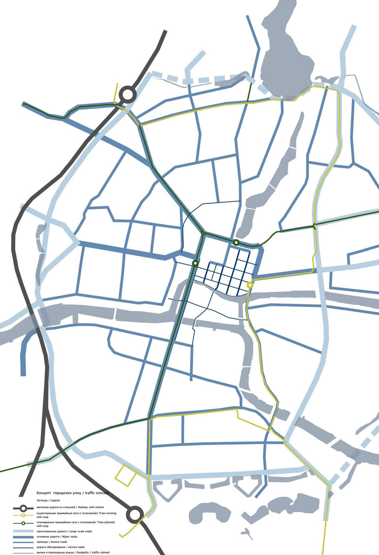
FREE SPACE AND FOOTPATHS NETWORK – The new city development forms spaces and spatial sequences rebuilding nowadays interrupted connections. Thus making it possible to walk directly from Kneipphof to the castle pond by crossing the river Pregel. For this the north–south-axes of access have generous sidewalks on both sides. And in contrast, the east-west-connections describe traffic calmed zones with limited use and roadside planting, underlining their character of an attractive boulevard. From the public squares, three stops for a new or refurbished tram network can easily be reached. In this way the cultural center in the " Heart of the City" is very well connected with the commercial center (Victory Square), the Sports Center, the Museum of the Oceans, the Kneipphof-Island with its cathedral, the FIFA World Cup area and the urban green spaces.
INFRASTRUCTURE – Moscow and Lenin Prospekt are prim elements of development in the new concept, too. The main difference to today's traffic solution consists in the removal of the Moscow Prospekt in the area of today's park in the southern part of „Altstadt“. The newly emerging roads are based on the historical course and are linked on three sides by a kind of a clasp to the primary network. So the whole area is connected to this system by the north-south-axes like a harp. The crossing pedestrian connections are basically passable for special vehicles of the fire brigade, the medical care and the waste disposal. An advantage of this urban planning concept is the fact that its solution is independent of ideas about demolition or preservation ofthe bridge over the Kneipphof-Island, because the bridge is not relevant for the concept. For the sake of a well-kept townscape, urban development, and also the intended traffic reduction in the central part of the city it has to be considered to remove the bridge perspectively. Therefore it will be possible to realize a building development at Kneipphof, for example according to the idea of a critical reconstruction with several historic buildings, such as the town hall, the high school and the university or with a partial development of residential buildings. With the exception of short-term parking street parking should be prohibited throughout the hole inner-city district. Parking is generally provided below ground level.
For this purpose, the course of the natural terrain can be used to advantage. Furthermore, the parking system depends on the character and size of the functional units - the northern district (offices, hotels, cultural facilities) with larger and connected underground car parks, arranged across several levels, in contrast to the southern plots (residential buildings) with even more smaller underground garages being separated from each other. In addition, the system of parking can be supplemented by some (with a maximum of 3) multi-storey car parks at the periphery of the area and in connection with the office-buildings. The technical supply and disposal happens uncomplicated, caused by the proposed urban grid (continuing, for instance, with the water supply and disposal, the electrical and data network). And finally, the reconstruction of the course of the historical and natural terrain will be highly suitable for a natural drainage.
- Arquitectos
- Osterwold°Schmidt
- Localização
- Kaliningrad, Russia
- Ano
- 2014

